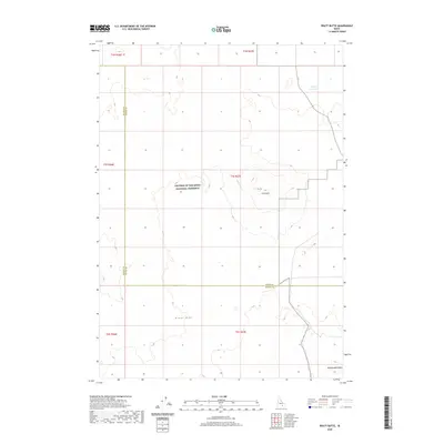
2020 Map of Pratt Butte
USGS Topo · Published 2020About this map
Craters Of The Moon National Preserve dominates this portion of the Idaho landscape, showcasing the geological intensity of the Eastern Snake River Plain. The terrain is defined by the Great Rift, a massive volcanic fissure system that bisects the region and influences the placement of local landmarks. Standing as prominent volcanic features are Pratt Butte and Rattlesnake Butte, which rise above the surrounding lava fields and high-desert scrub. The boundary between Blaine and Butte counties runs vertically through the western portion of the sheet, cutting through sections of the preserve. While the area is largely characterized by its volcanic history, small-scale water management is evident at Heifer Reservoir in the northeast, providing a rare point of managed surface water in an otherwise arid and geologically complex environment.
Find a feature on this map
8 named features on this map. Tap any name to fly to it.
Don’t see what you’re looking for? This feature index may not catch every label — zoom into the map to look around manually.
Map Details
Editions of this 2020 Pratt Butte Map
This is the sole edition of this map. No revisions or reprints were ever made.
Other maps of this area

1955 · Idaho Falls
USGS Topo · 1:250,000

1958 · Idaho Falls
USGS Topo · 1:250,000

1972 · Quaking Aspen Butte
USGS Topo · 1:24,000

1972 · Antelope Lake
USGS Topo · 1:24,000

1972 · Pratt Butte
USGS Topo · 1:24,000

1972 · Bear Park East
USGS Topo · 1:24,000

1972 · Bear Park West
USGS Topo · 1:24,000

1972 · Fingers Butte
USGS Topo · 1:24,000

1972 · Serviceberry Butte
USGS Topo · 1:24,000
1973 · Fissure Butte
USGS Topo · 1:24,000