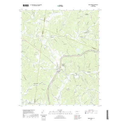
2019 Map of Primm Springs
USGS Topo · Published 2019About this map
Lick Creek and its many winding tributaries dictate the rugged character of the landscape where Hickman, Maury, and Williamson Counties meet. The terrain is a dense network of ridges and hollows, such as Hominy Ridge and Boneyard Hollow, which shaped the early settlement patterns of rural Tennessee. Small communities and crossroads like Kinderhook and Beasley Crossroads serve as focal points in this agrarian setting. A prominent modern and historical corridor, the Natchez Trace Pkwy and the accompanying Natchez Trace National Scenic Trail, cuts diagonally through the center of the sheet, following the ancient path of the Old Natchez Trce.
Find a feature on this map
159 named features on this map. Tap any name to fly to it.
Don’t see what you’re looking for? This feature index may not catch every label — zoom into the map to look around manually.
Map Details
Editions of this 2019 Primm Springs Map
This is the sole edition of this map. No revisions or reprints were ever made.
Other maps of this area

1901 · Colombia
USGS Topo · 1:125,000

1936 · Godwin
USGS Topo · 1:24,000

1936 · Williamsport
USGS Topo · 1:24,000

1936 · Primm
USGS Topo · 1:24,000

1936 · Littlelot
USGS Topo · 1:24,000

1936 · Theta
USGS Topo · 1:24,000

1936 · Greenfield Bend
USGS Topo · 1:24,000

1936 · Craigfield
USGS Topo · 1:24,000

1936 · Lyles
USGS Topo · 1:24,000

1940 · Godwin
USGS Topo · 1:24,000