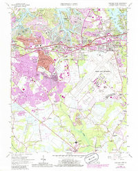
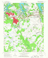
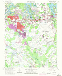
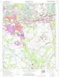
1965 Map of Princess Anne
USGS Topo · Published 1986About this map
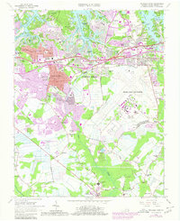
Oceana Naval Air Station dominates the central and eastern portions of this mid-1960s landscape, serving as a massive anchor for the rapid suburbanization of Virginia Beach. Purple-tinted revisions from the early 1980s illustrate a period of intense growth, where once-open tracts between Princess Anne Plaza and Thalia Village became densely residential neighborhoods like Birchwood Gardens and Pecan Gardens. This transition is particularly evident near the Virginia Beach city center, where municipal expansion is marked by the Virginia Beach City Hall and the sprawling Tidewater Community College. Away from the emerging urban core, the map preserves older rural identities at Murdens Corner and Dam Neck Corner. The tidal reaches of the Eastern Branch Lynnhaven River and Linkhorn Bay contrast with the straightening lines of the Norfolk Southern railroad, showing the persistent influence of coastal geography on local infrastructure.
Find a feature on this map
102 named features on this map. Tap any name to fly to it.
Don’t see what you’re looking for? This feature index may not catch every label — zoom into the map to look around manually.
Map Details
Editions of this 1965 Princess Anne Map
6 editions found

Other maps of this area

1893 · Virginia Beach
USGS Topo · 1:125,000

1907 · Norfolk
USGS Topo · 1:125,000

1916 · Back Bay
USGS Topo · 1:62,500

1918 · Cape Henry
USGS Topo · 1:62,500

1919 · Cape Henry
USGS Topo · 1:62,500

1939 · Moyock
USGS Topo · 1:62,500

1943 · Back Bay
USGS Topo · 1:62,500

1946 · Moyock
USGS Topo · 1:62,500

1946 · Eastville
USGS Topo · 1:250,000

1946 · Currituck Sound
USGS Topo · 1:250,000