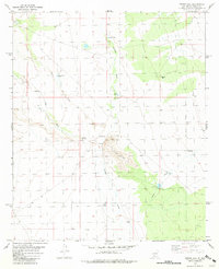
1981 Map of Prisor Hill
USGS Topo · Published 1981About this map
Aleman Ranch sits at the northern edge of this high desert landscape, characterized by an extensive system of drainages and critical water infrastructure. In an environment defined by aridity, the placement of numerous catchments and wells reflects the essential needs of ranching in the early 1980s. Significant seasonal waterways like Aleman Draw, Jornada Draw, and Lyons Draw converge across the terrain, leading toward the prominent elevation of Prisor Hill. Named water sources such as Santa Fe East Well, Badger Tank, and Jody Tank are scattered throughout, providing a clear picture of how water management was mapped to sustain livestock operations. The eastern boundary is notably defined by the New Mexico Principal Meridian, serving as a foundational survey line for the entire region.
Find a feature on this map
16 named features on this map. Tap any name to fly to it.
Don’t see what you’re looking for? This feature index may not catch every label — zoom into the map to look around manually.
Map Details
Editions of this 1981 Prisor Hill Map
This is the sole edition of this map. No revisions or reprints were ever made.
Other maps of this area

1916 · Tonuco
USGS Topo · 1:125,000

1916 · Salinas Peak
USGS Topo · 1:125,000

1932 · Tonuco
USGS Topo · 1:125,000

1948 · Sowell
USGS Topo · 1:62,500

1948 · Chicken Well
USGS Topo · 1:62,500

1954 · Tularosa
USGS Topo · 1:250,000

1955 · Las Cruces
USGS Topo · 1:250,000

1958 · Las Cruces
USGS Topo · 1:250,000

1958 · Tularosa
USGS Topo · 1:250,000

1959 · Engle
USGS Topo · 1:62,500