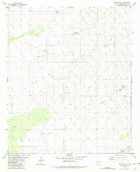
1981 Map of Prisor Well
USGS Topo · Published 1981About this map
Prisor Well and a series of livestock-watering tanks define the landscape of this high-desert region on the border of Sierra and Dona Ana counties. The terrain is marked by seasonal drainages including Lyons Draw and Blackshire Draw, which cut through the arid flats. This 1981 edition shows the area just after its 1970s field checking, revealing a network of infrastructure essential for ranching and resource management in a dry climate. Landmarks such as the CCC Tank suggest the enduring legacy of Depression-era land improvements in the New Mexico backcountry. Much of the eastern portion of the map is occupied by the White Sands Missile Range, reflecting the significant military presence that shaped land use in this part of the state during the late twentieth century. Remote access is limited to intermittent tracks and a single Jeep Trail, illustrating the isolated nature of the basin floor.
Find a feature on this map
13 named features on this map. Tap any name to fly to it.
Don’t see what you’re looking for? This feature index may not catch every label — zoom into the map to look around manually.
Map Details
Editions of this 1981 Prisor Well Map
This is the sole edition of this map. No revisions or reprints were ever made.
Other maps of this area

1916 · Tonuco
USGS Topo · 1:125,000

1916 · Salinas Peak
USGS Topo · 1:125,000

1932 · Tonuco
USGS Topo · 1:125,000

1948 · Sowell
USGS Topo · 1:62,500

1948 · Chicken Well
USGS Topo · 1:62,500

1948 · Kaylor Mountain
USGS Topo · 1:62,500

1948 · Black Top Mountain
USGS Topo · 1:62,500

1954 · Tularosa
USGS Topo · 1:250,000

1955 · Las Cruces
USGS Topo · 1:250,000

1958 · Las Cruces
USGS Topo · 1:250,000