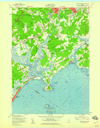
1959 Map of Prouts Neck
USGS Topo · Published 1959About this map
Prouts Neck and the surrounding coastline of Cumberland County reveal a landscape defined by the intersection of early tourism and the working maritime economy. This 1959 survey shows the area during a period of transition, where established shore communities like Old Orchard Beach and Higgins Beach sit alongside active industrial sites, such as the numerous Borrow Pits and Clay Pits dotting the interior. The coastal geography is complex, shaped by the tidal reaches of the Nonesuch River and Spurwink River, which carve through Winnocks Neck and around Plummer Island.
Find a feature on this map
104 named features on this map. Tap any name to fly to it.
Don’t see what you’re looking for? This feature index may not catch every label — zoom into the map to look around manually.
Map Details
Editions of this 1959 Prouts Neck Map
This is the sole edition of this map. No revisions or reprints were ever made.
Other maps of this area

1891 · Portland
USGS Topo · 1:62,500

1891 · Biddeford
USGS Topo · 1:62,500

1893 · Biddeford
USGS Topo · 1:62,500

1893 · Portland
USGS Topo · 1:62,500

1893 · Casco Bay
USGS Topo · 1:62,500

1914 · Portland
USGS Topo · 1:48,000

1914 · Casco Bay
USGS Topo · 1:48,000

1916 · Portland
USGS Topo · 1:62,500

1916 · Casco Bay
USGS Topo · 1:62,500

1916 · Portland And Vicinity
USGS Topo · 1:62,500