
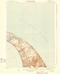
1898 Map of Provincetown
USGS Topo · Published 1940About this map
The maritime landscape of Provincetown and Truro is defined here by the network of nineteenth-century coastal defenses and navigational aids that once protected the outer tip of Cape Cod. Surveyed just before the turn of the century by Marcus Baker, the map documents a dense concentration of federal safety installations, including the Highland and Peaked Hill Bar life saving stations. These sites, along with prominent landmarks like Highland Light and Race Point Light, reflect the era's intensive effort to secure one of the Atlantic's most hazardous shorelines. Inland, the map reveals a mosaic of freshwater bodies like Shank Painter Pond and Duck Pond tucked behind the dunes of Pilgrim Beach. The settlement of North Truro remains a quiet outpost, while the larger harbor community sits protected behind the Hook, illustrating the geographic isolation and reliance on the sea that shaped these communities before modern infrastructure.
Find a feature on this map
33 named features on this map. Tap any name to fly to it.
Don’t see what you’re looking for? This feature index may not catch every label — zoom into the map to look around manually.
Map Details
Editions of this 1898 Provincetown Map
This is the sole edition of this map. No revisions or reprints were ever made.
Other maps of this area

1887 · Wellfleet
USGS Topo · 1:62,500

1887 · Provincetown
USGS Topo · 1:62,500

1889 · Provincetown
USGS Topo · 1:62,500

1889 · Wellfleet
USGS Topo · 1:62,500

1893 · Wellfleet
USGS Topo · 1:62,500

1942 · Cape Cod Bay
USGS Topo · 1:125,000

1942 · Nauset
USGS Topo · 1:125,000

1944 · Provincetown
USGS Topo · 1:31,680

1944 · Wellfleet
USGS Topo · 1:31,680
1944 · North Truro
USGS Topo · 1:31,680