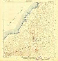
1928 Map of Puako
USGS Topo · Published 1943About this map
Puu Anahulu Homesteads and the neighboring Puukala-Kaulana Homesteads reflect the early 20th-century agrarian settlement patterns along the leeward coast of Hawaii. This survey, conducted by A. Fankhauser, E. G. Wingate, and K. Simeona, documents a landscape shaped by volcanic history, most notably the prominent Lava flow of 1801 cutting through the Kaupulehu region. Along the shoreline, small coastal settlements like Puako and Kiholo are connected by a network of trails, while the interior reaches toward the heights of Puu Waawaa. The map details a transition from the coastal bays, such as Anaehoomalu Bay and Kiholo Bay, to the ranching lands exemplified by Huehue Ranch. Transportation of the era is captured through the Keamoku Road and the Old Puuwaawaa Road, illustrating how inland transit moved through the South Kohala District and North Kona District before modern infrastructure.
Find a feature on this map
79 named features on this map. Tap any name to fly to it.
Don’t see what you’re looking for? This feature index may not catch every label — zoom into the map to look around manually.
Map Details
Editions of this 1928 Puako Map
2 editions found
Other maps of this area

1913 · Kohala
USGS Topo · 1:62,500

1916 · Kohala
USGS Topo · 1:62,500

1916 · Waipio
USGS Topo · 1:62,500

1927 · Kaohe
USGS Topo · 1:62,500

1928 · Puako
USGS Topo · 1:62,500

1928 · Kailua
USGS Topo · 1:62,500

1930 · Kaohe
USGS Topo · 1:62,500

1954 · Hawaii North
USGS Topo · 1:250,000

1956 · Puu Hinai
USGS Topo · 1:24,000

1956 · Kamuela
USGS Topo · 1:24,000