
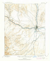
1894 Map of Pueblo
USGS Topo · Published 1957About this map
The Pueblo townsite stands as a major high-plains industrial and rail hub in the late 19th century, situated at the confluence of the Arkansas River and Fountain Creek. This 1894 survey documents a landscape being rapidly transformed by irrigation and heavy transit, highlighted by the prominent Bessemer Ditch and the concentration of rail lines including the Denver and Rio Grande RR and the Atchison Topeka and Santa Fe RR. Beyond the urban center, the map reveals a rural transition into the foothills, where the San Isabel National Forest begins and small outposts like Beulah and Three R Ranch dot the western terrain.
Find a feature on this map
60 named features on this map. Tap any name to fly to it.
Don’t see what you’re looking for? This feature index may not catch every label — zoom into the map to look around manually.
Map Details
Editions of this 1894 Pueblo Map
2 editions found
Other maps of this area

1889 · Canon City
USGS Topo · 1:125,000

1889 · Huerfano Park
USGS Topo · 1:125,000

1891 · Walsenburg
USGS Topo · 1:125,000

1891 · Pueblo
USGS Topo · 1:125,000

1891 · Nepesta
USGS Topo · 1:125,000

1891 · Apishapa
USGS Topo · 1:125,000

1892 · Huerfano Park
USGS Topo · 1:125,000

1892 · Canon City
USGS Topo · 1:125,000

1893 · Nepesta
USGS Topo · 1:125,000

1893 · Apishapa
USGS Topo · 1:125,000