
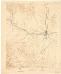
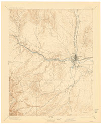
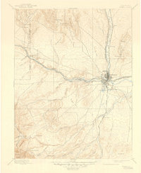
1897 Map of Pueblo
USGS Topo · Published 1897About this map
Pueblo sits at the vital junction of the Canyon Branch Arkansas River and Fountain Creek, serving as a late-19th-century industrial and transportation hub. The landscape is defined by a dense concentration of rail lines, including the Atchison Topeka and Santa Fe R.R. and the Denver and Rio Grande R.R., which converge near the city center and Bessemer Junction. This heavy infrastructure supported the development of the Bessemer Ditch and Lake Minnequa, indicating the early engineering efforts required to sustain industry and agriculture in the semi-arid high plains.
Find a feature on this map
61 named features on this map. Tap any name to fly to it.
Don’t see what you’re looking for? This feature index may not catch every label — zoom into the map to look around manually.
Map Details
Editions of this 1897 Pueblo Map
4 editions found
Other maps of this area

1889 · Canon City
USGS Topo · 1:125,000

1889 · Huerfano Park
USGS Topo · 1:125,000

1891 · Walsenburg
USGS Topo · 1:125,000

1891 · Pueblo
USGS Topo · 1:125,000

1891 · Nepesta
USGS Topo · 1:125,000

1891 · Apishapa
USGS Topo · 1:125,000

1892 · Huerfano Park
USGS Topo · 1:125,000

1892 · Canon City
USGS Topo · 1:125,000

1893 · Nepesta
USGS Topo · 1:125,000

1893 · Apishapa
USGS Topo · 1:125,000