1934 Map of Pulaski
USGS Topo · Published 1934About this map
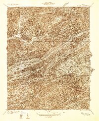
The town of Pulaski serves as a commercial hub in the lower right quadrant of this survey, where the Norfolk and Western railway and State Highway 100 navigate the base of Draper Mountain. The landscape is dominated by the dramatic southwest-to-northeast orientation of the Appalachian ridges, including Big Walker Mountain and Little Walker Mountain, which dictate the paths of waterways like Walker Creek and Wolf Creek.
Find a feature on this map
53 named features on this map. Tap any name to fly to it.
Don’t see what you’re looking for? This feature index may not catch every label — zoom into the map to look around manually.
Map Details
Editions of this 1934 Pulaski Map
This is the sole edition of this map. No revisions or reprints were ever made.
Other maps of this area

1887 · Pocahontas
USGS Topo · 1:125,000

1889 · Hillsville
USGS Topo · 1:125,000

1889 · Wytheville
USGS Topo · 1:125,000

1890 · Dublin
USGS Topo · 1:125,000

1891 · Pocahontas
USGS Topo · 1:125,000

1891 · Dublin
USGS Topo · 1:125,000

1892 · Hillsville
USGS Topo · 1:125,000

1892 · Wytheville
USGS Topo · 1:125,000

1894 · Pocahontas
USGS Topo · 1:125,000

1895 · Pocahontas
USGS Topo · 1:125,000