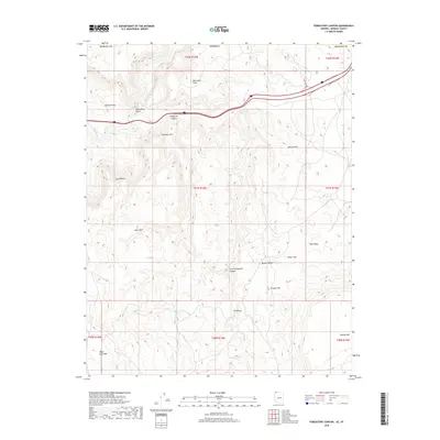
2018 Map of Purgatory Canyon
USGS Topo · Published 2018About this map
Purgatory Canyon and the surrounding high desert of Mohave County dominate this 2018 landscape, where the northern drainage of the Virgin River cuts through an intricate system of gulches and knolls. The terrain is defined by a series of prominent high points, including Starvation Point, Yellow Knolls, and Grey Points, which overlook the expansive Mojave Desert floor. A significant natural landmark, Shivwits Arch, sits just south of the canyon, while the presence of the State Line Reservoir near the northern boundary reflects the managed water resources of this arid border region. The southern portion of the map transitions into higher elevations marked by Black Rock Mountain and Mokaac Mountain. This survey details the complex network of 4WD trails and remote tracks that navigate through areas like The Dives and Big Valley, illustrating how modern infrastructure follows the traditional contours of the land.
Find a feature on this map
27 named features on this map. Tap any name to fly to it.
Don’t see what you’re looking for? This feature index may not catch every label — zoom into the map to look around manually.
Map Details
Editions of this 2018 Purgatory Canyon Map
This is the sole edition of this map. No revisions or reprints were ever made.
Other maps of this area

1885 · St. George
USGS Topo · 1:250,000

1886 · Mt. Trumbull
USGS Topo · 1:250,000

1891 · St. George
USGS Topo · 1:250,000

1892 · Mt. Trumbull
USGS Topo · 1:250,000

1953 · Cedar City
USGS Topo · 1:250,000

1953 · Grand Canyon
USGS Topo · 1:250,000

1954 · Wolf Hole Mtn. NW
USGS Topo · 1:24,000

1954 · Beaver Dam Mts SE
USGS Topo · 1:24,000

1954 · Wolf Hole Mtn. NE
USGS Topo · 1:24,000

1954 · St. George
USGS Topo · 1:62,500