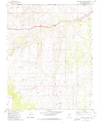
1979 Map of Purgatory Canyon
USGS Topo · Published 1980About this map
The Virgin River carves through this northern Arizona landscape, marking a transition between the elevated plateaus and deep canyon systems of Mohave County during the late 1970s. The map illustrates a region defined by its harsh nomenclature and ranching heritage, featuring Blakes Lambing Grounds in the northwest and Starvation Point overlooking the river valley. Transportation and water management are central themes, seen in the Black Rock Interchange and the State Line Reservoir near the Utah border. The topography is meticulously detailed, from the sharp ridges of Grey Points and the Lime Hills to the winding depths of Purgatory Canyon and Little Purgatory. Geologic and agricultural landmarks like Mokaac Mountain, Dinner Flat, and a lone Corral provide grounding for local history and environmental study.
Find a feature on this map
26 named features on this map. Tap any name to fly to it.
Don’t see what you’re looking for? This feature index may not catch every label — zoom into the map to look around manually.
Map Details
Editions of this 1979 Purgatory Canyon Map
This is the sole edition of this map. No revisions or reprints were ever made.
Other maps of this area

1885 · St. George
USGS Topo · 1:250,000

1886 · Mt. Trumbull
USGS Topo · 1:250,000

1891 · St. George
USGS Topo · 1:250,000

1892 · Mt. Trumbull
USGS Topo · 1:250,000

1953 · Cedar City
USGS Topo · 1:250,000

1953 · Grand Canyon
USGS Topo · 1:250,000

1954 · Wolf Hole Mtn. NW
USGS Topo · 1:24,000

1954 · Beaver Dam Mts SE
USGS Topo · 1:24,000

1954 · Wolf Hole Mtn. NE
USGS Topo · 1:24,000

1954 · St. George
USGS Topo · 1:62,500