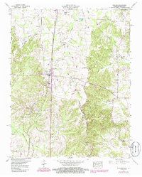
1950 Map of Puryear
USGS Topo · Published 1985About this map
The Seaboard railroad corridor anchors the settlement of Puryear in this mid-century portrait of Henry County, Tennessee, near the Kentucky border. At this time, the community was centered around the Puryear Sch, a local substation, and the nearby Union Grove Church. To the east, Conyersville and Foundry Hill serve as smaller rural nodes amidst a landscape defined by the Tenn Valley Divide. This topographic survey captures a dense network of family history markers, including the Underwood Cem, Bradley Cem, and Old Antioch Cem. The hydrological character of the region is well-defined by the Clarks River and the North Fork Blood River, which carve through the terrain as it transitions toward the North Fork Obion River in the south.
Find a feature on this map
73 named features on this map. Tap any name to fly to it.
Don’t see what you’re looking for? This feature index may not catch every label — zoom into the map to look around manually.
Map Details
Editions of this 1950 Puryear Map
3 editions found

Other maps of this area

1936 · Conyersville
USGS Topo · 1:24,000

1936 · Buchanan
USGS Topo · 1:24,000

1936 · Hazel
USGS Topo · 1:24,000

1936 · New Concord
USGS Topo · 1:24,000

1936 · Crossland
USGS Topo · 1:24,000

1936 · Lynn Grove
USGS Topo · 1:24,000

1936 · Paris
USGS Topo · 1:24,000

1936 · Springville
USGS Topo · 1:24,000

1938 · Springville
USGS Topo · 1:24,000

1942 · New Concord
USGS Topo · 1:24,000