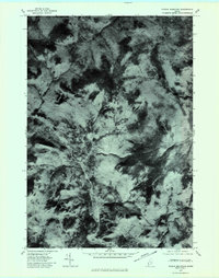
1977 Map of Puzzle Mountain
USGS Topo · Published 1983About this map
North Newry sits as the primary point of settlement within this late-1970s orthophotograph of the Oxford County uplands. The landscape is defined by the sharp topographical contrast between the river valley and the surrounding heights. The Bear River winds through the central corridor, following a narrow path that dictates the placement of the local road network and the small cluster of buildings at North Newry. To the east and north, the terrain rises steeply toward the summits of Puzzle Mountain and Long Mountain. This aerial perspective, captured in October 1977, reveals the density of the forest cover and the drainage patterns of smaller tributaries like Gardner Brook as they descend toward the main valley floor, offering a precise view of the rural Maine landscape before more recent developments.
Find a feature on this map
5 named features on this map. Tap any name to fly to it.
Don’t see what you’re looking for? This feature index may not catch every label — zoom into the map to look around manually.
Map Details
Editions of this 1977 Puzzle Mountain Map
This is the sole edition of this map. No revisions or reprints were ever made.
Other maps of this area

1911 · Bryant Pond
USGS Topo · 1:62,500

1914 · Bethel
USGS Topo · 1:62,500

1914 · Bryant Pond
USGS Topo · 1:62,500

1927 · Rumford
USGS Topo · 1:48,000

1930 · Rumford
USGS Topo · 1:62,500

1940 · Bethel
USGS Topo · 1:62,500

1941 · Bethel
USGS Topo · 1:62,500

1942 · Bryant Pond
USGS Topo · 1:62,500

1943 · Old Speck Mtn
USGS Topo · 1:62,500

1945 · Old Speck Mtn
USGS Topo · 1:62,500