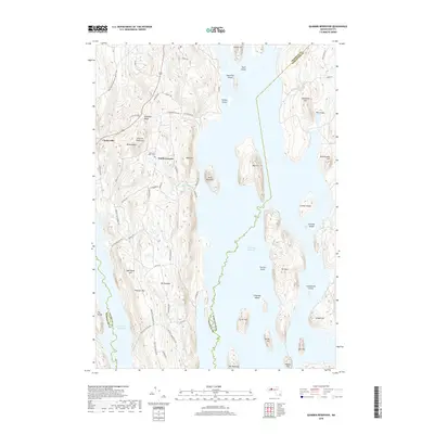
2018 Map of Quabbin Reservoir
USGS Topo · Published 2018About this map
Quabbin Reservoir dominates this central Massachusetts landscape, its expansive waters surrounding numerous interior high points that now exist as islands. The Prescott Peninsula extends southward through the center of the sheet, preserved as a restricted wilderness area. Along its spine, legacy roads like Prescott Shutesbury Rd and Prescott Pelham Rd trace the routes of a former community, leading past the Mountain View Cem and the small settlement of North Prescott. On the western edge, the New England National Scenic Trail winds through the hills near Cooleyville. The map illustrates the massive scale of the mid-20th-century reservoir project, where formerly prominent peaks such as Mt Zion, Southworth Island, and Snell Island have been isolated by the flooded valley of the Swift River, creating a unique archipelago of landforms.
Find a feature on this map
69 named features on this map. Tap any name to fly to it.
Don’t see what you’re looking for? This feature index may not catch every label — zoom into the map to look around manually.
Map Details
Editions of this 2018 Quabbin Reservoir Map
This is the sole edition of this map. No revisions or reprints were ever made.
Other maps of this area

1887 · Warwick
USGS Topo · 1:62,500

1887 · Belchertown
USGS Topo · 1:62,500

1887 · Winchendon
USGS Topo · 1:62,500

1887 · Barre
USGS Topo · 1:62,500

1889 · Barre
USGS Topo · 1:62,500

1889 · Warwick
USGS Topo · 1:62,500

1890 · Belchertown
USGS Topo · 1:62,500

1890 · Winchendon
USGS Topo · 1:62,500

1893 · Belchertown
USGS Topo · 1:62,500

1894 · Winchendon
USGS Topo · 1:62,500