
1967 Map of Quabbin Reservoir
USGS Topo · Published 1979About this map
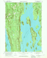
Quabbin Reservoir dominates this central Massachusetts landscape, where the rising waters of the mid-20th century transformed hills into islands. The topography is defined by significant elevations such as Mount Zion, Soapstone Hill, and Packard Mtn, many of which stand as landmasses within the reservoir or along its intricate shoreline. Human settlement is concentrated in the northwestern reaches, where the villages of New Salem and Cooleyville are situated near the Shutesbury State Forest. Smaller, more isolated sites like North Prescott and Lincoln remain visible, alongside the Mtn View Cem and a Gaging Sta. The southern portion of the map is notable for the Baffle Dam and the distinct terrain of Den Hill, reflecting the massive engineering effort required to secure the region's water supply. Roads like Prescott Road and Underhill Road provide the primary access through this heavily wooded and protected watershed area.
Find a feature on this map
41 named features on this map. Tap any name to fly to it.
Don’t see what you’re looking for? This feature index may not catch every label — zoom into the map to look around manually.
Map Details
Editions of this 1967 Quabbin Reservoir Map
2 editions found
Other maps of this area

1887 · Warwick
USGS Topo · 1:62,500

1887 · Belchertown
USGS Topo · 1:62,500

1887 · Winchendon
USGS Topo · 1:62,500

1887 · Barre
USGS Topo · 1:62,500

1889 · Barre
USGS Topo · 1:62,500

1889 · Warwick
USGS Topo · 1:62,500

1890 · Belchertown
USGS Topo · 1:62,500

1890 · Winchendon
USGS Topo · 1:62,500

1893 · Belchertown
USGS Topo · 1:62,500

1894 · Winchendon
USGS Topo · 1:62,500