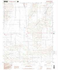
1996 Map of Quail Spring
USGS Topo · Published 1999About this map
The Owlhead Mountains dominate the northern landscape of this Mojave Desert region, meeting the Quail Mountains to the south. This terrain is defined by its arid hydrology, featuring the eponymous Quail Spring and ephemeral basins such as Lost Lake and Dry Lake. The map reveals a history of mineral exploration through several labeled Prospects and a singular Prospect located in the southwestern canyons. These markings indicate the search for resources in a difficult environment where water sources like the spring were vital for survival. The southern edge of the survey is defined by the Fort Irwin Military Reservation Boundary, illustrating the intersection of natural desert topography and 20th-century federal land management in San Bernardino County.
Find a feature on this map
16 named features on this map. Tap any name to fly to it.
Don’t see what you’re looking for? This feature index may not catch every label — zoom into the map to look around manually.
Map Details
Editions of this 1996 Quail Spring Map
This is the sole edition of this map. No revisions or reprints were ever made.
Other maps of this area

1933 · Avawatz Mountains
USGS Topo · 1:250,000

1947 · Trona
USGS Topo · 1:250,000

1948 · Trona
USGS Topo · 1:250,000

1948 · Quail Mountains
USGS Topo · 1:62,500

1948 · Leach Lake
USGS Topo · 1:62,500

1950 · Wingate Wash
USGS Topo · 1:62,500

1950 · Confidence Hills
USGS Topo · 1:62,500

1951 · Quail Mountains
USGS Topo · 1:62,500
1951 · Leach Lake
USGS Topo · 1:62,500

1953 · Trona
USGS Topo · 1:250,000