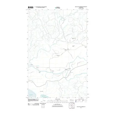
2011 Map of Quillayute Prairie
USGS Topo · Published 2011About this map
The Quillayute River basin dominates this coastal landscape, where the confluence of the Sol Duc River and Bogachiel River forms the main waterway leading toward the Pacific Ocean. This 2011 survey captures the unique topography of the Quillayute Prairie and Little Quillayute Prairie, clearings in the dense forest that have long served as focal points for local activity. The settlement of Quillayute and the nearby Quillayute Cemetery represent the area's inland community, while Mora and the Mora Campground mark the transition into Olympic National Park near the coast. Infrastructure such as the Quillayute State Airport, with its distinctive taxiways like Delta Wing Dr, highlights the region's aviation and logistical importance. Researchers can also trace family-named roads and landmarks, including Mina Smith Rd and the Leyendecker Picnic Area, which reflect the localized history of this Olympic Peninsula river system.
Find a feature on this map
47 named features on this map. Tap any name to fly to it.
Don’t see what you’re looking for? This feature index may not catch every label — zoom into the map to look around manually.
Map Details
Editions of this 2011 Quillayute Prairie Map
This is the sole edition of this map. No revisions or reprints were ever made.
Other maps of this area

1935 · Ozette Lake
USGS Topo · 1:62,500

1935 · Lake Pleasant
USGS Topo · 1:62,500

1939 · Forks
USGS Topo · 1:62,500

1942 · Ozette Lake
USGS Topo · 1:62,500

1942 · Lake Pleasant
USGS Topo · 1:62,500

1943 · Copalis Beach
USGS Topo · 1:250,000

1951 · Copalis Beach
USGS Topo · 1:250,000

1953 · Cape Flattery
USGS Topo · 1:250,000

1956 · La Push
USGS Topo · 1:62,500

1956 · Ozette Lake
USGS Topo · 1:62,500