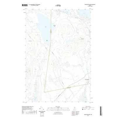
2021 Map of Ragged Mountain
USGS Topo · Published 2021About this map
Upper Jo-Mary Lake and its prominent Black Island dominate the northwestern reaches of this Maine landscape, where the boundary between Piscataquis and Penobscot counties cuts through the dense lake-and-stream network. The small settlement of West Seboeis serves as a lone hub of activity in the southeastern corner, situated near the shores of Seboeis Lake and the southern tip of W Schoodic Stream. This map illustrates the transition from high points like Ragged Mtn and the unique formation at Balancing Rock to the low, sprawling wetlands of the Wangan Brook Deadwater. The timber and recreation-oriented road system, including Jo-Mary Lake Rd and Turkey Tail Rd, provides the primary access to remote waters like Turkey Tail Lake and Upper Ebemee Lake.
Find a feature on this map
31 named features on this map. Tap any name to fly to it.
Don’t see what you’re looking for? This feature index may not catch every label — zoom into the map to look around manually.
Map Details
Editions of this 2021 Ragged Mountain Map
This is the sole edition of this map. No revisions or reprints were ever made.
Other maps of this area

1940 · Sebec
USGS Topo · 1:48,000

1943 · Sebec
USGS Topo · 1:62,500

1947 · Schoodic
USGS Topo · 1:62,500

1949 · Schoodic
USGS Topo · 1:62,500

1951 · Norcross
USGS Topo · 1:62,500

1952 · Jo-Mary Mountain
USGS Topo · 1:62,500

1954 · Millinocket
USGS Topo · 1:250,000

1958 · Millinocket
USGS Topo · 1:250,000

1960 · Millinocket
USGS Topo · 1:250,000
1978 · Norcross
USGS Topo · 1:24,000