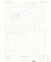
1970 Map of Ramah South
USGS Topo · Published 1973About this map
Ramah sits at the intersection of the Chicago Rock Island and Pacific railroad and the Ramah Highway in this 1970 survey of eastern El Paso County. The landscape is defined by the ephemeral drainages of Big Sandy Creek and Antelope Creek, which feed into the Ramah Reservoir. This water management infrastructure, including the reservoir and various spillways, was critical to the ranching and agricultural operations of the high plains.
Find a feature on this map
22 named features on this map. Tap any name to fly to it.
Don’t see what you’re looking for? This feature index may not catch every label — zoom into the map to look around manually.
Map Details
Editions of this 1970 Ramah South Map
This is the sole edition of this map. No revisions or reprints were ever made.
Other maps of this area

1893 · Big Springs
USGS Topo · 1:125,000

1953 · Denver
USGS Topo · 1:250,000

1954 · Pueblo
USGS Topo · 1:250,000

1957 · Denver
USGS Topo · 1:250,000

1957 · Pueblo
USGS Topo · 1:250,000

1958 · Pueblo
USGS Topo · 1:250,000

1958 · Denver
USGS Topo · 1:250,000

1960 · Denver
USGS Topo · 1:250,000

1962 · Pueblo
USGS Topo · 1:250,000

1966 · Pueblo
USGS Topo · 1:250,000