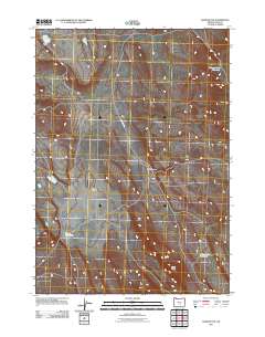
2011 Map of Rams Butte
USGS Topo · Published 2011About this map
Rams Butte rises above the high desert landscape of Lake County, anchoring a terrain defined by critical water sources and historic routes. In this 2011 survey, the Wagontire Rd is the primary artery through a region where life and travel are dictated by the presence of catchments like the Burrows Lake Reservoir and the Rams Butte Reservoir. The landscape is etched with the drainage of Black Canyon and the open expanse of Jew Valley, illustrating the sparse but vital water infrastructure of the Oregon high desert. Features such as the Curve Waterhole highlight the necessity of reliable points of interest for livestock and navigation in an otherwise arid expanse. This map documents a high-desert environment where topography and water-management sites remain the most significant landmarks.
Find a feature on this map
7 named features on this map. Tap any name to fly to it.
Don’t see what you’re looking for? This feature index may not catch every label — zoom into the map to look around manually.
Map Details
Editions of this 2011 Rams Butte Map
This is the sole edition of this map. No revisions or reprints were ever made.
Other maps of this area

1955 · Crescent
USGS Topo · 1:250,000

1955 · Burns
USGS Topo · 1:250,000

1957 · Crescent
USGS Topo · 1:250,000

1958 · Crescent
USGS Topo · 1:250,000

1958 · Burns
USGS Topo · 1:250,000

1959 · Burns
USGS Topo · 1:250,000

1970 · Crescent
USGS Topo · 1:250,000

1980 · Wagontire Mtn West
USGS Topo · 1:24,000

1980 · Round Top Butte
USGS Topo · 1:24,000
1981 · Tired Horse Butte
USGS Topo · 1:24,000