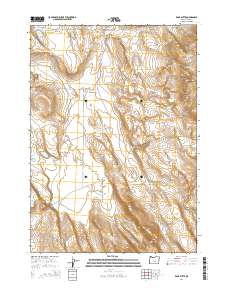
2014 Map of Rams Butte
USGS Topo · Published 2014About this map
Rams Butte stands as the primary landmark in this high desert landscape of Lake County, where water management is etched into the terrain through man-made and natural catchments. The 2014 topography reveals a network of vital water points, from the Burrows Lake Reservoir and Rams Butte Reservoir to the more primitive Curve Waterhole. These features, along with Jew Valley and the deep cut of Black Canyon, illustrate the critical infrastructure required for ranching and survival in Oregon's arid interior. Transportation is represented by established routes such as Black Canyon Rd and the Benjamin Lk and Carrolwell tracks, which connect distant sections of the Public Land Survey System. The map documents a sparsely settled region defined by its geological depressions like Sand Hollow and ephemeral features such as Oblong Lk.
Find a feature on this map
18 named features on this map. Tap any name to fly to it.
Don’t see what you’re looking for? This feature index may not catch every label — zoom into the map to look around manually.
Map Details
Editions of this 2014 Rams Butte Map
This is the sole edition of this map. No revisions or reprints were ever made.
Other maps of this area

1955 · Crescent
USGS Topo · 1:250,000

1955 · Burns
USGS Topo · 1:250,000

1957 · Crescent
USGS Topo · 1:250,000

1958 · Crescent
USGS Topo · 1:250,000

1958 · Burns
USGS Topo · 1:250,000

1959 · Burns
USGS Topo · 1:250,000

1970 · Crescent
USGS Topo · 1:250,000

1980 · Wagontire Mtn West
USGS Topo · 1:24,000

1980 · Round Top Butte
USGS Topo · 1:24,000
1981 · Tired Horse Butte
USGS Topo · 1:24,000