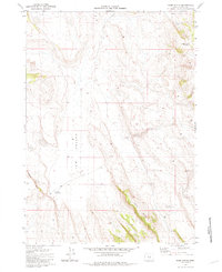
1981 Map of Rams Butte
USGS Topo · Published 1981About this map
Jew Valley dominates the central portion of this high-desert landscape in Lake County, where water management is the primary signature on the land. The topography is defined by the volcanic rise of Rams Butte in the south and the sharp basaltic edge of the Black Rim to the west. Evidence of ranching and livestock operations is found in the scattered water sources vital to this arid region, including Currie Waterhole, Eades Well, and the Sand Hollow drainage. These features, along with artificial catchments like Burnt Lake Reservoir and Rams Butte Reservoir, illustrate the human effort to sustain use of this remote terrain. The map captures a transition point between broad flat basins and the uplifted buttes that characterize the Oregon high desert in the late twentieth century.
Find a feature on this map
8 named features on this map. Tap any name to fly to it.
Don’t see what you’re looking for? This feature index may not catch every label — zoom into the map to look around manually.
Map Details
Editions of this 1981 Rams Butte Map
This is the sole edition of this map. No revisions or reprints were ever made.
Other maps of this area

1955 · Crescent
USGS Topo · 1:250,000

1955 · Burns
USGS Topo · 1:250,000

1957 · Crescent
USGS Topo · 1:250,000

1958 · Crescent
USGS Topo · 1:250,000

1958 · Burns
USGS Topo · 1:250,000

1959 · Burns
USGS Topo · 1:250,000

1970 · Crescent
USGS Topo · 1:250,000

1980 · Wagontire Mtn West
USGS Topo · 1:24,000

1980 · Round Top Butte
USGS Topo · 1:24,000
1981 · Tired Horse Butte
USGS Topo · 1:24,000