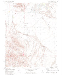
1979 Map of Ramsey Spring
USGS Topo · Published 1980About this map
Gabbs Valley dominates this high-desert landscape in the late 1970s, bounded by the northern reaches of the Gabbs Valley Range. This arid expanse is defined by a series of intermittent drainage systems, including the prominent Gabbs Wash and Finger Rock Wash, which channel water toward the basin floor. Mining interests are evident in the northern Black Hills, where the Lithia Mine and Rita Mine were established near the county line. The presence of these operations, along with scattered features like the Borrow Pit, suggests a landscape focused on mineral extraction and infrastructure maintenance during this era.
Find a feature on this map
19 named features on this map. Tap any name to fly to it.
Don’t see what you’re looking for? This feature index may not catch every label — zoom into the map to look around manually.
Map Details
Editions of this 1979 Ramsey Spring Map
This is the sole edition of this map. No revisions or reprints were ever made.
Other maps of this area

1909 · Hawthorne
USGS Topo · 1:250,000

1911 · Hawthorne
USGS Topo · 1:250,000

1915 · Hawthorne
USGS Topo · 1:250,000

1948 · Walker Lake
USGS Topo · 1:250,000

1957 · Walker Lake
USGS Topo · 1:250,000

1962 · Walker Lake
USGS Topo · 1:250,000

1964 · Walker Lake
USGS Topo · 1:250,000
1979 · Win Wan Flat
USGS Topo · 1:24,000
1979 · Mount Annie SE
USGS Topo · 1:24,000
1979 · Mt. Ferguson
USGS Topo · 1:24,000