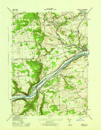
1946 Map of Randall
USGS Topo · Published 1946About this map
The Mohawk River corridor dominates this 1940s landscape, serving as a narrow artery for the state's most critical transportation infrastructure. This segment of the valley illustrates the evolution of inland navigation, showing the New York State Barge Canal running parallel to the older, dry sections of the Erie Canal (Abandoned). The heavy industrial and transit focus is further evidenced by the New York Central rail line and the Fonda Johnstown and Gloversville RR, which link the industrial centers of Fonda, Fultonville, and Johnstown.
Find a feature on this map
43 named features on this map. Tap any name to fly to it.
Don’t see what you’re looking for? This feature index may not catch every label — zoom into the map to look around manually.
Map Details
Editions of this 1946 Randall Map
This is the sole edition of this map. No revisions or reprints were ever made.
Other maps of this area

1896 · Fonda
USGS Topo · 1:62,500

1898 · Fonda
USGS Topo · 1:62,500

1898 · Canajoharie
USGS Topo · 1:62,500

1900 · Canajoharie
USGS Topo · 1:62,500

1901 · Lassellsville
USGS Topo · 1:62,500

1902 · Canajoharie
USGS Topo · 1:62,500

1902 · Fonda
USGS Topo · 1:62,500

1903 · Gloversville
USGS Topo · 1:62,500

1903 · Lassellsville
USGS Topo · 1:62,500

1943 · Gloversville
USGS Topo · 1:62,500