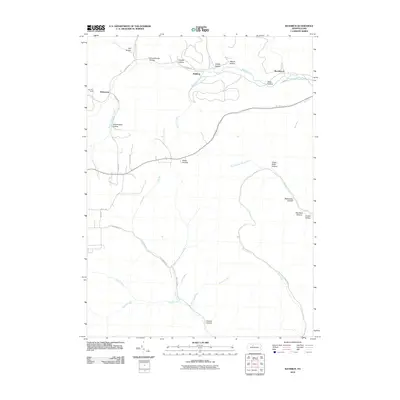
2010 Map of Rathbun
USGS Topo · Published 2010About this map
West Creek and its many winding tributaries define this portion of Elk County, carving a dense network of hollows through the plateau. Small settlements like Rathbun, Beechwood, and Swissmont are concentrated along the northern corridor following the creek and its adjacent roadways. The terrain is marked by numerous named drainages such as Hellfire Run, Sawdust Run, and Dents Run, which suggest the area's historical ties to the timber industry and backcountry camps like Bear Run Camp.
Find a feature on this map
40 named features on this map. Tap any name to fly to it.
Don’t see what you’re looking for? This feature index may not catch every label — zoom into the map to look around manually.
Map Details
Editions of this 2010 Rathbun Map
This is the sole edition of this map. No revisions or reprints were ever made.
Other maps of this area

1935 · Mt. Jewett
USGS Topo · 1:48,000

1940 · Mt. Jewett
USGS Topo · 1:62,500

1941 · Benezette
USGS Topo · 1:62,500

1941 · Ridgway
USGS Topo · 1:62,500

1943 · Benezette
USGS Topo · 1:62,500

1944 · Ridgway
USGS Topo · 1:62,500

1948 · Crosby
USGS Topo · 1:62,500

1948 · Wildwood Fire Tower
USGS Topo · 1:24,000

1948 · Rich Valley
USGS Topo · 1:24,000
1950 · Rich Valley
USGS Topo · 1:24,000