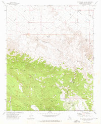
1972 Map of Rattlesnake Canyon
USGS Topo · Published 1976About this map
San Bernardino National Forest dominates the southern half of this landscape, where the high ridges of the Granite Peaks and Tip Top Mountain overlook the arid expanse of Johnson Valley to the north. Surveyed in the early 1970s, the map reveals a rugged backcountry accessible primarily by a network of jeep trails and footpaths. This era of land use is marked by scattered resource extraction, with numerous Mines and Prospects dotting the slopes, particularly near Rattlesnake Canyon. Water sources are vital landmarks in this high-desert environment, identified by distinctive names such as Two Hole Spring, One Hole Spring, and the clustered Viscera Springs. The presence of a Radio Facility near the southern boundary reflects the modern infrastructure beginning to reach these high elevations during the mid-20th century.
Find a feature on this map
28 named features on this map. Tap any name to fly to it.
Don’t see what you’re looking for? This feature index may not catch every label — zoom into the map to look around manually.
Map Details
Editions of this 1972 Rattlesnake Canyon Map
4 editions found
Other maps of this area

1901 · Southern California Sheet No. 1
USGS Topo · 1:250,000

1902 · San Gorgonio
USGS Topo · 1:125,000

1904 · Southern California Sheet No. 1
USGS Topo · 1:250,000

1947 · Lucerne Valley
USGS Topo · 1:62,500

1949 · Lucerne Valley
USGS Topo · 1:62,500

1953 · San Bernardino
USGS Topo · 1:250,000

1954 · San Gorgonio Mountain
USGS Topo · 1:62,500

1955 · Old Woman Springs
USGS Topo · 1:62,500

1955 · Morongo Valley
USGS Topo · 1:62,500

1956 · San Bernardino
USGS Topo · 1:250,000