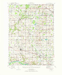
1945 Map of Ravenna
USGS Topo · Published 1973About this map
Coopersville and Ravenna serve as central hubs in this mid-century portrait of Muskegon and Ottawa counties. The landscape is characterized by a dense network of rural one-room schoolhouses and country churches, reflecting a period of active local community life before the consolidation of rural districts. The Pere Marquette RR cuts through the terrain, connecting agricultural settlements like Conklin and Casnovia to regional markets. To the south, the Grand River snakes along the border near Eastmanville and Lamont, while the northern reaches are drained by the winding Crockery Creek. The map meticulously preserves the locations of numerous family-named landmarks and institutions, from the Conklin High Sch to several municipal burying grounds such as Hilton Cem and McNitt Cem, providing a detailed look at the region's social and physical infrastructure at the end of the Second World War.
Find a feature on this map
100 named features on this map. Tap any name to fly to it.
Don’t see what you’re looking for? This feature index may not catch every label — zoom into the map to look around manually.
Map Details
Editions of this 1945 Ravenna Map
3 editions found
Other maps of this area

1914 · Grand Rapids
USGS Topo · 1:62,500

1918 · Cedar Springs
USGS Topo · 1:62,500

1929 · Holland
USGS Topo · 1:62,500

1930 · Muskegon
USGS Topo · 1:62,500

1932 · Holland
USGS Topo · 1:62,500

1936 · Muskegon
USGS Topo · 1:62,500

1943 · Cedar Springs
USGS Topo · 1:62,500

1943 · Grand Rapids
USGS Topo · 1:62,500

1945 · Ravenna
USGS Topo · 1:62,500

1954 · Milwaukee
USGS Topo · 1:250,000