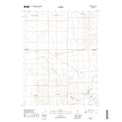
2018 Map of Rawhide
USGS Topo · Published 2018About this map
The high-desert mining district of Rawhide sits at the center of this 2018 survey, straddling the border of Churchill and Mineral counties. The landscape is defined by the complex topography of the Sand Springs Range and the Rawhide Hills, where numerous named peaks like Balloon Hill, Grutt Hill, and Hooligan Hill cluster around the historic settlement area. This region's history is written into the terrain, from the Rawhide Cem to the colorful local naming conventions found in Stingaree Gulch and Crazy Hill. The map meticulously tracks the elevation changes across Chicago Mtn and Buckskin Mtn, providing a clear picture of the land that once supported a massive silver and gold boom. To the northwest, the Barnett Hills rise above the basin, while the southern reaches are dominated by Squaw Peak and Black Eagle Hill, illustrating the isolation and elevation that characterized this portion of Nevada's Great Basin.
Find a feature on this map
25 named features on this map. Tap any name to fly to it.
Don’t see what you’re looking for? This feature index may not catch every label — zoom into the map to look around manually.
Map Details
Editions of this 2018 Rawhide Map
This is the sole edition of this map. No revisions or reprints were ever made.
Other maps of this area

1908 · Carson Sink
USGS Topo · 1:250,000

1909 · Hawthorne
USGS Topo · 1:250,000

1910 · Carson Sink
USGS Topo · 1:250,000

1911 · Hawthorne
USGS Topo · 1:250,000

1915 · Hawthorne
USGS Topo · 1:250,000

1948 · Walker Lake
USGS Topo · 1:250,000

1951 · Allen Springs
USGS Topo · 1:62,500

1957 · Walker Lake
USGS Topo · 1:250,000

1957 · Reno
USGS Topo · 1:250,000

1959 · Reno
USGS Topo · 1:250,000