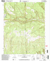
2001 Map of Ray Mesa
USGS Topo · Published 2004About this map
Ray Mesa defines the high desert landscape along the border of Utah and Colorado, captured here as it appeared in the late 20th century. This portion of the Manti-La Sal National Forest is heavily marked by the region's mid-century uranium and vanadium mining boom. The map reveals an intricate network of specialized resource extraction, featuring notable sites such as the Vanadium Queen Mine, Blue Cap Mine, and the Saint Patrick Mine.
Find a feature on this map
29 named features on this map. Tap any name to fly to it.
Don’t see what you’re looking for? This feature index may not catch every label — zoom into the map to look around manually.
Map Details
Editions of this 2001 Ray Mesa Map
This is the sole edition of this map. No revisions or reprints were ever made.
Other maps of this area

1885 · La Sal
USGS Topo · 1:250,000

1916 · Paradox Valley
USGS Topo · 1:125,000

1922 · Paradox Valley
USGS Topo · 1:125,000

1948 · Roc Creek
USGS Topo · 1:24,000

1948 · Paradox
USGS Topo · 1:24,000

1949 · Paradox
USGS Topo · 1:24,000

1949 · Roc Creek
USGS Topo · 1:24,000
1949 · Anderson Mesa
USGS Topo · 1:24,000
1950 · Anderson Mesa
USGS Topo · 1:24,000

1954 · Mt Peale 1 SE
USGS Topo · 1:24,000