
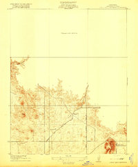
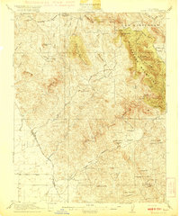
1942 Map of Raymond
USGS Topo · Published 1942About this map
Raymond serves as a focal point for this section of the Sierra Nevada foothills, where the Southern Pacific railroad meets a landscape defined by ranching and resource extraction. The presence of the Madera Granite Quarry and the Daulton Copper Mine underscores the industrial activity that sustained local settlements during the early 1940s. A network of rural schools, including Union High School and Dennis Sch, alongside family-named outposts like Shaubach Ranch and Morris Ranch, illustrates the distributed nature of the community.
Find a feature on this map
61 named features on this map. Tap any name to fly to it.
Don’t see what you’re looking for? This feature index may not catch every label — zoom into the map to look around manually.
Map Details
Editions of this 1942 Raymond Map
This is the sole edition of this map. No revisions or reprints were ever made.
Other maps of this area

1912 · Mariposa
USGS Topo · 1:125,000

1916 · Sulphur Springs
USGS Topo · 1:24,000

1919 · Indian Gulch
USGS Topo · 1:48,000

1919 · Sulphur Springs
USGS Topo · 1:31,680

1919 · Raynor Creek
USGS Topo · 1:31,680
1919 · Little Table Mountain
USGS Topo · 1:31,680
1920 · Indian Gulch
USGS Topo · 1:62,500

1920 · Kismet
USGS Topo · 1:31,680

1921 · Daulton
USGS Topo · 1:31,680

1922 · Lanes Bridge
USGS Topo · 1:31,680
Featured Places
- Daulton, CA
- Lake Madera Country Estates, CA
- Yosemite Lakes, CA
- Yosemite Lakes Park, Yosemite Lakes
- Raymond, CA