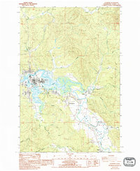
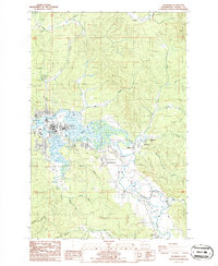
1986 Map of Raymond
USGS Topo · Published 1994About this map
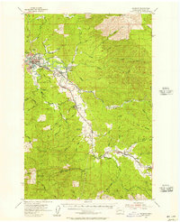
The Willapa River serves as the central artery for this mid-1980s Pacific County landscape, where the tidal flats and sloughs dictate the layout of industrial and residential areas. Raymond stands as the primary hub, characterized by its network of water-adjacent infrastructure including a Sewage Pond and multiple Substation sites. The map reveals a transition from the town's grid to the outlying settlements of East Raymond and Willapa, which follow the river's winding course inland.
Find a feature on this map
36 named features on this map. Tap any name to fly to it.
Don’t see what you’re looking for? This feature index may not catch every label — zoom into the map to look around manually.
Map Details
Editions of this 1986 Raymond Map
2 editions found
Other maps of this area

1938 · South Bend
USGS Topo · 1:62,500
1940 · Montesano
USGS Topo · 1:62,500

1940 · South Bend
USGS Topo · 1:62,500

1953 · Hoquiam
USGS Topo · 1:250,000
1955 · Montesano
USGS Topo · 1:62,500
1955 · Raymond
USGS Topo · 1:62,500
1955 · North Nemah
USGS Topo · 1:24,000
1955 · Aberdeen SE
USGS Topo · 1:24,000

1957 · Hoquiam
USGS Topo · 1:250,000
1957 · South Bend
USGS Topo · 1:24,000