
1946 Map of Rayne
USGS Topo · Published 1946About this map
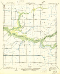
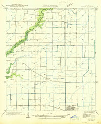
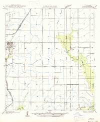
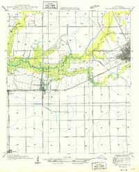
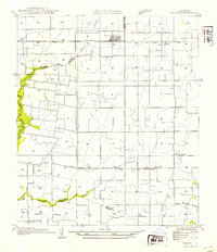
Rayne and eastern Crowley anchor this mid-century survey of the Acadia Parish prairie, where the landscape is defined by a rigorous grid of section lines and irrigation infrastructure. The transition from the settled town blocks to the surrounding agricultural tracts is marked by the path of the Southern Pacific and Texas and Pacific railroads, which facilitated the region's rice and produce economy. South of the main settlements, the community of Ebenezer is visible through the Ebenezer Sch and Ebenezer Ch, while further west sits Hebron Ch near Roller. The southern portion of the quadrangle reveals the winding, natural course of Bayou Queue De Tortue and Indian Bayou, which form the boundaries between Acadia, Lafayette, and Vermilion Parishes. This contrast between the straight-line precision of the inland Canal system and the organic curves of the bayous highlights the engineering efforts to manage water in this coastal prairie environment.
Find a feature on this map
25 named features on this map. Tap any name to fly to it.
Don’t see what you’re looking for? This feature index may not catch every label — zoom into the map to look around manually.
Map Details
Editions of this 1946 Rayne Map
This is the sole edition of this map. No revisions or reprints were ever made.
Other maps of this area

1934 · Duson
USGS Topo · 1:31,680

1935 · Branch
USGS Topo · 1:31,680
1946 · Morse
USGS Topo · 1:31,680

1946 · Leroy
USGS Topo · 1:31,680
1946 · Kaplan
USGS Topo · 1:31,680

1947 · Branch
USGS Topo · 1:31,680
1947 · Iota
USGS Topo · 1:31,680
1949 · Estherwood
USGS Topo · 1:31,680

1952 · Lake Charles
USGS Topo · 1:250,000
1954 · Duson
USGS Topo · 1:31,680