
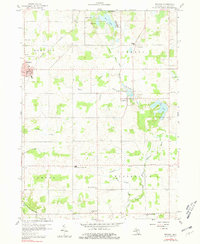
1959 Map of Reading
USGS Topo · Published 1960About this map
The town of Reading serves as a hub in this southern Michigan landscape, marked by its position along the New York Central railroad. Agricultural drainage patterns are evident through named systems like the Meade Drain and Prouty Drain, which feed into the St Joseph River. These waterworks reflect the intensive land use of the late 1950s, supporting a countryside dotted with small rural education and religious centers. Notable sites for local history include the Amish Sch, West Woodbridge Ch, and the Camden-Frontier Sch. The southern portion of the map is particularly rich in family-named burial grounds like Devine Cem and Sheldon Cem, while the Cambria Millpond at Cambria suggests the importance of water-based industry in the township's development. Glacial features such as Bear Lake and Cub Lake highlight the area's natural topography amidst the surveyed farm plots.
Find a feature on this map
38 named features on this map. Tap any name to fly to it.
Don’t see what you’re looking for? This feature index may not catch every label — zoom into the map to look around manually.
Map Details
Editions of this 1959 Reading Map
2 editions found
Other maps of this area

1914 · Pioneer
USGS Topo · 1:62,500

1939 · Clear Lake
USGS Topo · 1:24,000

1940 · Clear Lake
USGS Topo · 1:24,000

1944 · Pioneer
USGS Topo · 1:62,500

1953 · Fort Wayne
USGS Topo · 1:250,000

1956 · Fort Wayne
USGS Topo · 1:250,000

1959 · Hillsdale
USGS Topo · 1:24,000

1959 · North Adams
USGS Topo · 1:24,000

1959 · Frontier
USGS Topo · 1:24,000
1960 · Camden
USGS Topo · 1:24,000