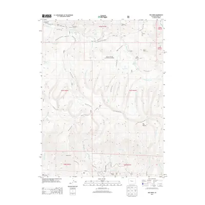
2013 Map of Red Creek
USGS Topo · Published 2013About this map
White River National Forest defines the character of this high-elevation landscape, where a dense network of drainages and named gulches reveals a history of land use and exploration. Notable topographical features like Red Table Mountain and Gyp Hill dominate the terrain, while the presence of named water sources such as Antones Spring, Allred Spring, and the Lede Reservoir points to the importance of water management in this arid environment. The map details an extensive trail system, including the Sundell Trail 1863, Red Creek Trail 425.1, and McKenzie Gulch Trail 1869.1, which trace the paths of early travel through the mountains. Small-scale development is evident at the Red Creek Campground and the small settlement area of Red Hill, showing how recreation and local habitation have integrated into the national forest land over time.
Find a feature on this map
56 named features on this map. Tap any name to fly to it.
Don’t see what you’re looking for? This feature index may not catch every label — zoom into the map to look around manually.
Map Details
Editions of this 2013 Red Creek Map
This is the sole edition of this map. No revisions or reprints were ever made.
Other maps of this area

1909 · Mount Jackson
USGS Topo · 1:125,000

1911 · Mount Jackson
USGS Topo · 1:125,000

1957 · Leadville
USGS Topo · 1:250,000

1959 · Leadville
USGS Topo · 1:250,000

1960 · Leadville
USGS Topo · 1:250,000
1961 · Woody Creek
USGS Topo · 1:24,000

1961 · Ruedi
USGS Topo · 1:24,000
1961 · Toner Reservoir
USGS Topo · 1:24,000

1961 · Red Creek
USGS Topo · 1:24,000

1962 · Leadville
USGS Topo · 1:250,000