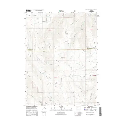
2016 Map of Red Elephant Point
USGS Topo · Published 2016About this map
The White River National Forest dominates this section of the Western Slope, where the boundary between Rio Blanco and Garfield counties bisects a landscape defined by high mesas and deep drainages. In the mid-2010s, this area remains a complex network of seasonal water sources and livestock infrastructure, evidenced by named sites like Janes Spring, Bloodsworth Pond, and Howey Reservoir. The terrain is marked by significant elevations such as Red Elephant Point and the expansive Coulter Mesa to the southeast. Historically significant transport routes are documented through the Ute Stock Driveway and the Wagon Road, reflecting the region's long-standing reliance on cattle and sheep ranching. From the depths of Red Canyon to the heights of Wells Ridge, the map identifies a specialized system of trails, including the W Miller Ridge Trail and the Middle Mountain Trail, which provided essential access for forest management and local land use.
Find a feature on this map
56 named features on this map. Tap any name to fly to it.
Don’t see what you’re looking for? This feature index may not catch every label — zoom into the map to look around manually.
Map Details
Editions of this 2016 Red Elephant Point Map
This is the sole edition of this map. No revisions or reprints were ever made.
Other maps of this area

1906 · Grand Hogback
USGS Topo · 1:125,000

1910 · Grand Hogback
USGS Topo · 1:125,000

1952 · Rio Blanco
USGS Topo · 1:24,000

1952 · Horse Mountain
USGS Topo · 1:24,000

1957 · Leadville
USGS Topo · 1:250,000

1959 · Leadville
USGS Topo · 1:250,000

1960 · Leadville
USGS Topo · 1:250,000

1962 · Leadville
USGS Topo · 1:250,000

1964 · Leadville
USGS Topo · 1:250,000
1966 · Thirteenmile Creek
USGS Topo · 1:24,000