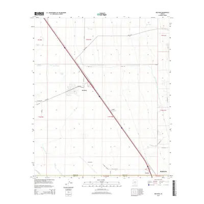
2014 Map of Red Rock
USGS Topo · Published 2014About this map
The Santa Cruz River and Los Robles Wash cut through this Sonoran desert landscape, illustrating the critical role of water management in Pinal and Pima counties. This modern topographic study shows the massive infrastructure of the Central Arizona Project Aqueduct running east-to-west across the terrain, contrasting with older cattle-era features like Wilmonts Pond and Double Tank. The settlement of Red Rock serves as a focal point near the Interstate corridor, while the expansive Pinal Airpark occupies a significant footprint in the southern portion of the quadrangle. Local road names such as E Missile Base Rd hint at the Cold War-era utility of this open desert, providing researchers with a detailed look at how transportation and military history have shaped the region south of the Suizo Wash.
Find a feature on this map
37 named features on this map. Tap any name to fly to it.
Don’t see what you’re looking for? This feature index may not catch every label — zoom into the map to look around manually.
Map Details
Editions of this 2014 Red Rock Map
This is the sole edition of this map. No revisions or reprints were ever made.
Other maps of this area

1934 · Tucson Mountains
USGS Topo · 1:125,000

1934 · Newman Peak
USGS Topo · 1:125,000

1947 · Cortaro
USGS Topo · 1:62,500

1947 · Red Rock
USGS Topo · 1:62,500

1956 · Tucson
USGS Topo · 1:250,000

1957 · Cortaro
USGS Topo · 1:62,500

1958 · Tucson
USGS Topo · 1:250,000

1959 · Tucson
USGS Topo · 1:250,000

1959 · Tortolita Mts
USGS Topo · 1:62,500
1959 · Silver Bell Peak
USGS Topo · 1:62,500