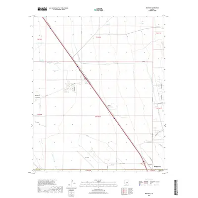
2018 Map of Red Rock
USGS Topo · Published 2018About this map
Pinal Airpark occupies a central position on this desert landscape, its runways and infrastructure situated just north of the border between Pinal and Pima Counties. The map reveals a complex water management system crucial to this arid region, most notably the massive Central Arizona Project Aqueduct which cuts through the terrain alongside the ephemeral Santa Cruz River. Small settlements and rail points like Red Rock and Avra are clustered along the major transportation corridor, while named landmarks like Wilmonts Pond and several livestock water stations such as Double Tank highlight the ranching history of the area. To the southeast, the outskirts of Marana and the locality of Nariska sit near the junction of rural routes and interstate infrastructure, illustrating the desert's transition from open range to specialized aviation and transit hubs.
Find a feature on this map
42 named features on this map. Tap any name to fly to it.
Don’t see what you’re looking for? This feature index may not catch every label — zoom into the map to look around manually.
Map Details
Editions of this 2018 Red Rock Map
This is the sole edition of this map. No revisions or reprints were ever made.
Other maps of this area

1934 · Tucson Mountains
USGS Topo · 1:125,000

1934 · Newman Peak
USGS Topo · 1:125,000

1947 · Cortaro
USGS Topo · 1:62,500

1947 · Red Rock
USGS Topo · 1:62,500

1956 · Tucson
USGS Topo · 1:250,000

1957 · Cortaro
USGS Topo · 1:62,500

1958 · Tucson
USGS Topo · 1:250,000

1959 · Tucson
USGS Topo · 1:250,000

1959 · Tortolita Mts
USGS Topo · 1:62,500
1959 · Silver Bell Peak
USGS Topo · 1:62,500