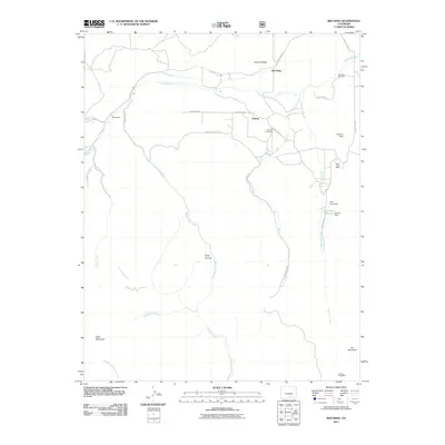
2011 Map of Red Wing
USGS Topo · Published 2011About this map
Red Wing and the neighboring settlements of Chama and Sharpsdale occupy this stretch of the Huerfano River valley in the years following the turn of the twenty-first century. The landscape is defined by a ranching and mining legacy, where irrigation features like Montez Ditch support the valley floor while the surrounding high ground contains industrial sites such as the Santa Rosa Mine, Mcintire Mine, and the Copper King Mine to the southeast. Local genealogy is anchored by the Gonzales Cemetery and Chama Cemetery, which serve the small communities nestled between prominent landmarks like Point of Rocks and the deep incisions of Manzanares Creek. The map documents a rugged network of drainage systems, including Martin Creek and Palo Duro Creek, which feed into the primary river corridor, illustrating the critical relationship between water management and high-desert habitation.
Find a feature on this map
35 named features on this map. Tap any name to fly to it.
Don’t see what you’re looking for? This feature index may not catch every label — zoom into the map to look around manually.
Map Details
Editions of this 2011 Red Wing Map
This is the sole edition of this map. No revisions or reprints were ever made.
Other maps of this area

1889 · Huerfano Park
USGS Topo · 1:125,000

1892 · Huerfano Park
USGS Topo · 1:125,000

1954 · Trinidad
USGS Topo · 1:250,000

1955 · Trinidad
USGS Topo · 1:250,000

1958 · Trinidad
USGS Topo · 1:250,000

1959 · Trinidad
USGS Topo · 1:250,000

1963 · La Veta Pass
USGS Topo · 1:24,000

1967 · Mosca Pass
USGS Topo · 1:24,000
1967 · Blanca Peak
USGS Topo · 1:24,000
1967 · Creager Reservoir
USGS Topo · 1:24,000