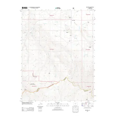
2013 Map of Red Wing
USGS Topo · Published 2013About this map
The Huerfano River flows across this high-altitude landscape, defining the northern valley where the small settlements of Red Wing and Chama are established. This 2013 survey illustrates a rural mountain economy sustained by water management features such as Montez Ditch and the McIntire Reservoir, essential for ranching and agriculture in Huerfano County. To the south, the terrain rises dramatically into the San Isabel National Forest, where peaks like Slide Mountain and Iron Mountain dominate the horizon alongside deep cuts like Bruenellie Canyon and Deep Canyon. Genealogists will find local history preserved at the Chama Cem and Gonzales Cem, while the inclusion of the Cascade Trail 1303 and various county roads indicates the modern recreational use of this rugged territory near the Costilla County line.
Find a feature on this map
41 named features on this map. Tap any name to fly to it.
Don’t see what you’re looking for? This feature index may not catch every label — zoom into the map to look around manually.
Map Details
Editions of this 2013 Red Wing Map
This is the sole edition of this map. No revisions or reprints were ever made.
Other maps of this area

1889 · Huerfano Park
USGS Topo · 1:125,000

1892 · Huerfano Park
USGS Topo · 1:125,000

1954 · Trinidad
USGS Topo · 1:250,000

1955 · Trinidad
USGS Topo · 1:250,000

1958 · Trinidad
USGS Topo · 1:250,000

1959 · Trinidad
USGS Topo · 1:250,000

1963 · La Veta Pass
USGS Topo · 1:24,000

1967 · Mosca Pass
USGS Topo · 1:24,000
1967 · Blanca Peak
USGS Topo · 1:24,000
1967 · Creager Reservoir
USGS Topo · 1:24,000