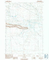
1990 Map of Redess
USGS Topo · Published 1990About this map
Wrights Point rises as a prominent landmark above the flat expanse of Harney Valley, a landscape defined by an intricate network of waterways and managed agricultural fields in the late 20th century. The complex hydrology of the high desert is visible in the branching paths of the East Fork Silvies River and West Fork Silvies River, which feed into various sloughs like Ford Slough and Boat Slough. Human activity in this arid basin is centered around livestock and ranching, evidenced by the Island Ranch and large tracts such as the Big Red S Field and Little Red S Fields. Evidence of earlier habitation persists at the Redess (Site) and the Sunset Valley Cem within the southern Sunset Valley area, providing specific locations for researchers tracking the lineage of families and homesteads in this part of Harney County.
Find a feature on this map
15 named features on this map. Tap any name to fly to it.
Don’t see what you’re looking for? This feature index may not catch every label — zoom into the map to look around manually.
Map Details
Editions of this 1990 Redess Map
This is the sole edition of this map. No revisions or reprints were ever made.
Other maps of this area

1955 · Burns
USGS Topo · 1:250,000

1958 · Burns
USGS Topo · 1:250,000

1959 · Burns
USGS Topo · 1:250,000

1959 · Harney
USGS Topo · 1:62,500

1959 · Dog Mountain
USGS Topo · 1:62,500

1959 · Lawen
USGS Topo · 1:62,500

1960 · Burns
USGS Topo · 1:62,500

1960 · Burns
USGS Topo · 1:24,000

1975 · Burns
USGS Topo · 1:24,000

1978 · Malheur Lake
USGS Topo · 1:100,000