
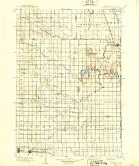
1899 Map of Redfield
USGS Topo · Published 1899About this map
Redfield serves as the primary rail hub on this Dakota landscape, situated at the junction of the Chicago and Northwestern R.R. and the Minn. and Central Dakota Line. The surrounding prairie is organized into named townships such as Groveland, Wheaton, and Burdette, reflecting the systematic settlement patterns of the late nineteenth century. To the south, Tulare and Bonilla line the St. Paul and Milwaukee R.R., while the western reaches are anchored by Miller.
Find a feature on this map
66 named features on this map. Tap any name to fly to it.
Don’t see what you’re looking for? This feature index may not catch every label — zoom into the map to look around manually.
Map Details
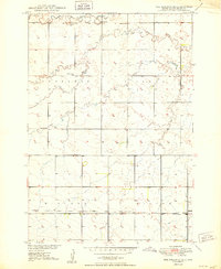
Editions of this 1899 Redfield Map
2 editions found
Other maps of this area

1895 · Byron
USGS Topo · 1:125,000

1895 · Aberdeen
USGS Topo · 1:125,000

1898 · Huron
USGS Topo · 1:125,000

1899 · Northville
USGS Topo · 1:125,000
1950 · Ree Heights SE
USGS Topo · 1:24,000
1950 · Vayland
USGS Topo · 1:24,000
1950 · Wessington
USGS Topo · 1:24,000
1950 · Vayland NW
USGS Topo · 1:24,000
1950 · Wessington NE
USGS Topo · 1:24,000
1951 · Orient
USGS Topo · 1:24,000
Featured Places
- Redfield, Redfield Township
- Miller, SD
- Tulare, Tulare Township
- St. Lawrence, SD
- Saint Lawrence, St. Lawrence