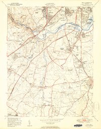
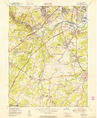
1950 Map of Relay
USGS Topo · Published 1950About this map
The Patapsco River serves as the central artery for this mid-century landscape, where industrial transit and residential growth converge at the borders of Baltimore, Anne Arundel, and Howard counties. The era's massive infrastructure shift is visible in the construction of the Washington-Baltimore Parkway, which carves through the terrain alongside established rail corridors like the Baltimore and Ohio RR and the Pennsylvania RR. Near the historic Thomas Viaduct, the communities of Relay and Elkridge maintain their traditional footings while the emergence of Baltimore Friendship International Airport signals a new chapter for the region.
Find a feature on this map
73 named features on this map. Tap any name to fly to it.
Don’t see what you’re looking for? This feature index may not catch every label — zoom into the map to look around manually.
Map Details
Editions of this 1950 Relay Map
2 editions found
Other maps of this area

1892 · Laurel
USGS Topo · 1:62,500

1892 · Ellicott
USGS Topo · 1:62,500

1894 · Ellicott
USGS Topo · 1:62,500

1894 · Laurel
USGS Topo · 1:62,500

1894 · Baltimore
USGS Topo · 1:62,500

1894 · Relay
USGS Topo · 1:62,500

1897 · Laurel
USGS Topo · 1:62,500

1899 · Baltimore
USGS Topo · 1:62,500

1904 · Baltimore
USGS Topo · 1:62,500

1906 · Ellicott
USGS Topo · 1:62,500