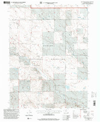
1997 Map of Reno Reservoir
USGS Topo · Published 2000About this map
The Pawnee National Grassland dominates this high plains landscape in Weld County, where water management is the primary marker of human activity. The map reveals a network of windmills and storage tanks necessary for ranching and conservation efforts in a semi-arid environment. Named landmarks like the Stonehouse Windmill and the Ashman Windmill (Double) serve as vital navigational and functional points across the terrain.
Find a feature on this map
26 named features on this map. Tap any name to fly to it.
Don’t see what you’re looking for? This feature index may not catch every label — zoom into the map to look around manually.
Map Details
Editions of this 1997 Reno Reservoir Map
This is the sole edition of this map. No revisions or reprints were ever made.
Other maps of this area

1908 · Eaton
USGS Topo · 1:125,000

1910 · Eaton
USGS Topo · 1:125,000

1954 · Greeley
USGS Topo · 1:250,000

1957 · Greeley
USGS Topo · 1:250,000

1958 · Greeley
USGS Topo · 1:250,000

1960 · Purcell
USGS Topo · 1:24,000

1961 · Greeley
USGS Topo · 1:250,000

1964 · Greeley
USGS Topo · 1:250,000

1965 · Greeley
USGS Topo · 1:250,000

1972 · Briggsdale
USGS Topo · 1:24,000