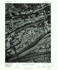
1977 Map of Reward
USGS Topo · Published 1979About this map
Reward and Seven Stars sit within a landscape defined by the rhythmic striping of contour-plowed fields in this 1977 orthophotograph. This specific map, produced in cooperation with the Soil Conservation Service, uses rectified aerial imagery to reveal the complex agricultural patterns across Buffalo Valley. The visual data provides an unusually clear record of land use and field boundaries during the late 1970s, showcasing how local farmers adapted their planting to the local topography. Bordering the southern portion of this rural mosaic is the dark, wooded ridgeline of Berry Mountain, which creates a sharp geographic boundary between the cultivated valley floor and the surrounding highlands. Unlike traditional topographic maps, this imagery records every barn, woodlot, and farm lane exactly as they stood during the spring of 1977.
Find a feature on this map
4 named features on this map. Tap any name to fly to it.
Don’t see what you’re looking for? This feature index may not catch every label — zoom into the map to look around manually.
Map Details
Editions of this 1977 Reward Map
This is the sole edition of this map. No revisions or reprints were ever made.
Other maps of this area

1892 · Harrisburg
USGS Topo · 1:62,500

1893 · Millersburg
USGS Topo · 1:62,500

1899 · Harrisburg
USGS Topo · 1:62,500

1907 · New Bloomfield
USGS Topo · 1:62,500

1907 · Millerstown
USGS Topo · 1:62,500

1924 · Harrisburg
USGS Topo · 1:62,500

1943 · Millerstown
USGS Topo · 1:62,500

1943 · Millersburg
USGS Topo · 1:62,500

1943 · Harrisburg
USGS Topo · 1:62,500

1943 · New Bloomfield
USGS Topo · 1:62,500
Featured Places
- Greenwood Township, PA
- Greenwood Township, PA
- Buffalo Township, PA
- Howe Township, PA
- Centerville, Liverpool Township