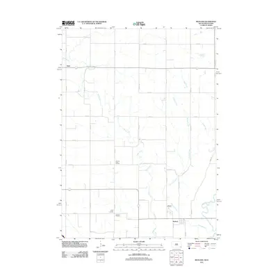
2011 Map of Richland
USGS Topo · Published 2011About this map
Brule Creek and its many meandering tributaries define this agricultural landscape in Union County, where the transition toward the Big Sioux River creates a network of drainages including Richland Creek and Sayles Creek. The area is anchored by the small settlements of Richland in the southeast and Spink in the northwest, connected by a rigid grid of section-line roads such as 475th Ave and 315th St. This 2011 survey reveals a landscape deeply tied to its early pioneer roots, evidenced by the high density of rural burial grounds scattered across the townships. Genealogists can trace local history through sites like the Old Brule Creek Cemetery, Union County Cemetery, Saint Paul Cemetery, and Richland Cemetery. The map captures the interface between modern county infrastructure and the natural riparian corridors that have shaped settlement patterns for generations.
Find a feature on this map
30 named features on this map. Tap any name to fly to it.
Don’t see what you’re looking for? This feature index may not catch every label — zoom into the map to look around manually.
Map Details
Editions of this 2011 Richland Map
This is the sole edition of this map. No revisions or reprints were ever made.
Other maps of this area

1898 · Elk Point
USGS Topo · 1:125,000

1901 · Elk Point
USGS Topo · 1:125,000

1907 · Elk Point
USGS Topo · 1:125,000

1955 · Sioux City
USGS Topo · 1:250,000

1958 · Sioux City
USGS Topo · 1:250,000

1959 · Sioux City
USGS Topo · 1:250,000

1963 · Elk Point
USGS Topo · 1:24,000

1963 · Elk Point NE
USGS Topo · 1:24,000

1964 · Burbank
USGS Topo · 1:24,000
1969 · Chatsworth
USGS Topo · 1:24,000