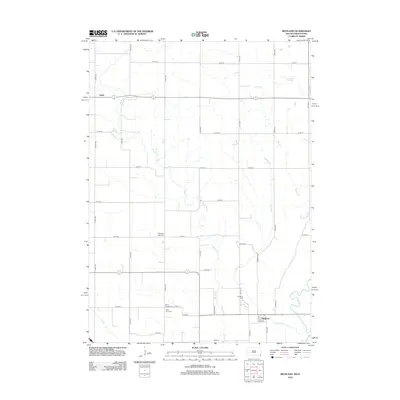
2012 Map of Richland
USGS Topo · Published 2012About this map
Brule Cr and its tributaries define the landscape of Union County in the early 21st century, carving a path through the agricultural grid south of Spink. This survey documents a rural landscape where family history is anchored by numerous burial grounds, including the Old Brule Creek Cem and Saint Paul Cem. The small settlement of Richland sits near the confluence of Richland Cr and the larger creek system, situated along State St. The transition from natural drainage to engineered water management is evident in the presence of the Big Ditch, which supports the surrounding farmland. The map provides a detailed view of the sectional road system, showing how the local infrastructure follows the land's hydrology while maintaining the rigid geometry of the Midwest's rural survey lines.
Find a feature on this map
33 named features on this map. Tap any name to fly to it.
Don’t see what you’re looking for? This feature index may not catch every label — zoom into the map to look around manually.
Map Details
Editions of this 2012 Richland Map
This is the sole edition of this map. No revisions or reprints were ever made.
Other maps of this area

1898 · Elk Point
USGS Topo · 1:125,000

1901 · Elk Point
USGS Topo · 1:125,000

1907 · Elk Point
USGS Topo · 1:125,000

1955 · Sioux City
USGS Topo · 1:250,000

1958 · Sioux City
USGS Topo · 1:250,000

1959 · Sioux City
USGS Topo · 1:250,000

1963 · Elk Point
USGS Topo · 1:24,000

1963 · Elk Point NE
USGS Topo · 1:24,000

1964 · Burbank
USGS Topo · 1:24,000
1969 · Chatsworth
USGS Topo · 1:24,000