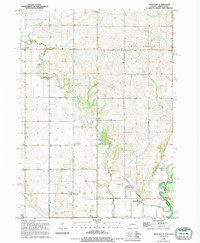
1994 Map of Richland
USGS Topo · Published 1995About this map
The Big Sioux River forms a jagged natural boundary between South Dakota and Iowa in this mid-1990s landscape, where the prairie topography is defined by the winding course of Brule Creek. The settlement of Spink sits in the northwest, while the community of Richland (anchored by the Richland Cem) occupies the southern bend of the river. The area is dense with local genealogy markers, including the Old Brule Creek Cem and Union Co Cem, reflecting a century of rural settlement. A designated Historical Site near the southern border and several country congregations, such as Pleasant Hill Chapel and St Paul Ch, point to the enduring social centers of the Brule and Sioux Valley townships. Industrial activity is limited to scattered Gravel Pits, while recreational use is noted at the Public Boat Ramp Access on the river’s edge.
Find a feature on this map
23 named features on this map. Tap any name to fly to it.
Don’t see what you’re looking for? This feature index may not catch every label — zoom into the map to look around manually.
Map Details
Editions of this 1994 Richland Map
This is the sole edition of this map. No revisions or reprints were ever made.
Other maps of this area

1898 · Elk Point
USGS Topo · 1:125,000

1901 · Elk Point
USGS Topo · 1:125,000

1907 · Elk Point
USGS Topo · 1:125,000

1955 · Sioux City
USGS Topo · 1:250,000

1958 · Sioux City
USGS Topo · 1:250,000

1959 · Sioux City
USGS Topo · 1:250,000

1963 · Elk Point
USGS Topo · 1:24,000

1963 · Elk Point NE
USGS Topo · 1:24,000

1964 · Burbank
USGS Topo · 1:24,000
1969 · Chatsworth
USGS Topo · 1:24,000