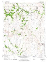
1965 Map of Richmond
USGS Topo · Published 1967About this map
Princeton and Richmond serve as the primary hubs of activity in this mid-1960s snapshot of the Kansas prairie, situated along the critical north-south corridor of the Atchison Topeka and Santa Fe railroad. The landscape is defined by the winding paths of Payne Creek and Middle Creek, which cut through the agricultural township boundaries of Homewood, Ohio, and Richmond. Cultural landmarks like the Acorn Community Hall and Central Community Hall reflect the rural social structure of the era, while Mt Olivet Ch stands as a focal point for the local community west of the rail line.
Find a feature on this map
21 named features on this map. Tap any name to fly to it.
Don’t see what you’re looking for? This feature index may not catch every label — zoom into the map to look around manually.
Map Details
Editions of this 1965 Richmond Map
2 editions found
Other maps of this area

1885 · Garnett
USGS Topo · 1:125,000

1885 · Lawrence
USGS Topo · 1:125,000

1889 · Lawrence
USGS Topo · 1:125,000

1894 · Garnett
USGS Topo · 1:125,000

1947 · Lawrence
USGS Topo · 1:250,000

1950 · Lawrence
USGS Topo · 1:250,000

1956 · Pomona
USGS Topo · 1:24,000

1956 · Williamsburg
USGS Topo · 1:24,000

1956 · Ottawa South
USGS Topo · 1:24,000

1956 · Lawrence
USGS Topo · 1:250,000